The Great Topographic Atlas of Catalonia 1:25,000 is the culmination of a work of more than 10 years, although its roots are older. The immediate precedent is the continuous map of the printed series published between late 2008 and mid-2015, consisting of 77 sheets, some of which have been reprinted on more than one occasion. Of the sheets published in an early period, the Parc Nacional d’Aigüestortes i Estany de Sant Maurici one was awarded by the International Cartographic Association (ICA/ACI) during its 18th International Conference held in Stockholm in 1997.
The Atlas brings together, in a single volume, the topographic map series 1:25,000 (MTC-25M), presented with 756 pages of cartography especially designed and prepared for this publication. The contents of the Atlas comes from the continuous map, from which the MTC-25M series is also obtained, although the information has been duly updated for the Atlas, especially in those areas where the changes have a greater impact on the configuration of the territory and in those aspects that may become more sensitive to citizenship: large infrastructures, communications network, protected natural reserves, territorial boundaries and geographical names.
The Atlas presents a toponymic index of 114,698 geographical names, a key piece for the search and localization of territorial information in cartography, where toponymy is categorized, hierarchized and highlighted according to the geographical reality of our context, reflecting the richness and language variants and official forms.
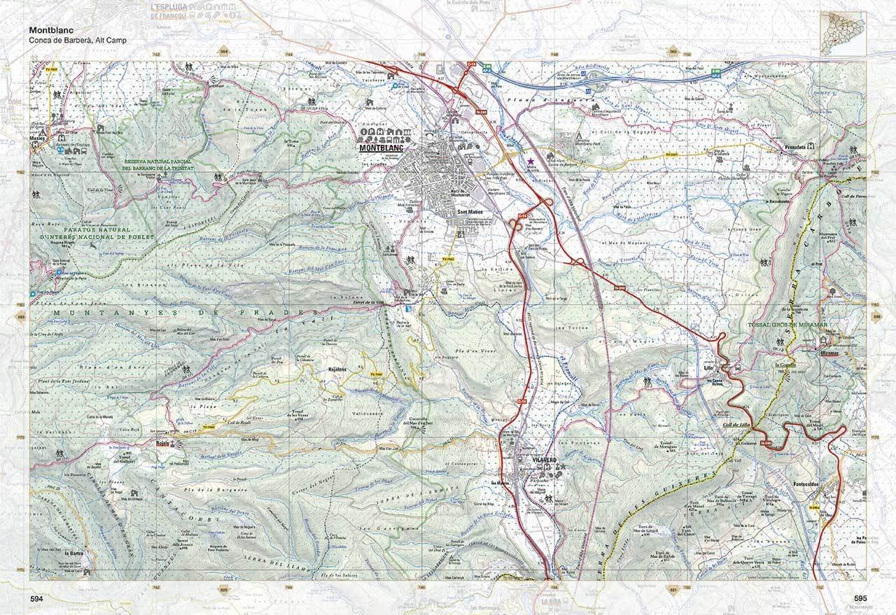
The topographic map shows the geographical reality of the territory it represents, separates the most relevant elements, it prioritizes and presents them in detail to achieve a depth of reading at different hierarchical levels and, obviously, with the metric and cartographic precision required by the scale.
The 1:25,000 is the smallest scale in which practically all geographic elements are represented at scale in our territory. In the Atlas some of these specific elements have been reinforced with specific symbology to highlight them and to extend, therefore, the use of the topographic map towards tourism and leisure time, since it is the most appropriate scale for this use in our environment.
This fact gives meaning to a thematic completeness based on the singularity and the local characterization on a topographic cartography of conventional and homogenous legend for the whole territory; Thus, this more particular contribution allows to offer information more linked to the territory, besides of a topographic map itself.
The contents of the Atlas is the result of a long working process, a process that begins with a photogrammetric flight to obtain the necessary images to begin the cartographic elaboration and culminating with the printing and binding of this work and, finally, its distribution. In the interim, there is an extensive and meticulous work of technical specialists from different disciplines in which each contributes with its grain of sand to reach a work of this magnitude.
The Atlas synthesizes the entire production process of an institution that has as one of its main missions the publication and dissemination of cartographic, topographic and thematic contents in different environments and formats. It is a task that requires an important base of interdisciplinary human capital. This collective work generates synergies that have also been understood in the context of the collaborative framework with other organisms of proximity to the territory for the data provision on roads, points of interest and services, and the design of hiking and bicycle trails.
In the Atlas, a geographical synthesis has also been included with the will to collect, with an overview, the main aspects that characterize Catalonia.
During the 28th International Cartographic Conference of the International Cartographic Association (ICA/ACI), held in Washington from July 2nd to 7th, 2017, the Great Topographic Atlas of Catalonia 1:25,000 was awarded with a distinction in the Atlas category.
")
")
")
")